 Article on creating custom routes and maps
In the digital age in which we live, technology gives us numerous tools to make our lives easier, and one of them is the possibility of creating personalized routes and maps. Whether it is to plan a trip, explore areas of interest or simply find the best route to reach our destination, there are various options that allow us to do so in a simple and effective way.
Google Maps: the most popular tool
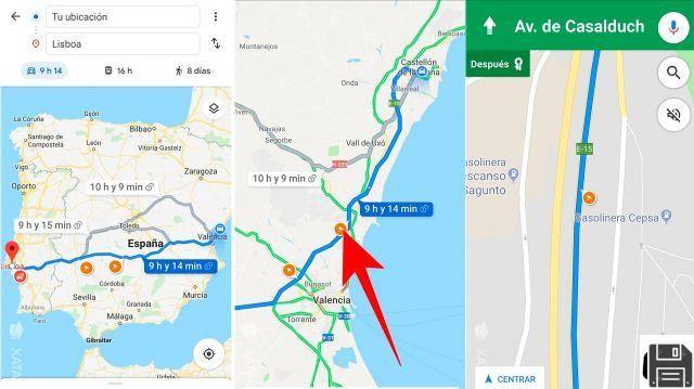
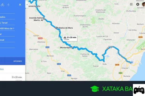
One of the most used tools to create personalized routes and maps is Google Maps. This platform allows us to trace travel routes, mark points of interest and obtain precise directions to reach our destination. In addition, it has an intuitive and easy-to-use interface, which makes it the preferred option for many users.
How to create a travel route in Google Maps?
To create a travel route in Google Maps, you simply have to follow the following steps:
- Open the Google Maps app on your device or access the website.
- Enter the origin and destination location in the corresponding fields.
- Click Get Directions and Google Maps will show you the best route to your destination.
- If you want to add additional stops to your route, you can do so by clicking the Add Destination button and adding the desired locations.
- Once you've set up your route, you can save it for easy access in the future.
Other tools to create custom routes and maps
In addition to Google Maps, there are other options that also allow us to create personalized routes and maps. Some of them are:
Printmaps – Create custom paper maps
Printmaps is a tool that allows us to create personalized paper maps. This option is ideal for those who prefer to have a physical map in their hands, either to take on a trip or simply for decoration. With Printmaps, you can select the area you want to include on your map, customize the layout, and get a high-quality printed version.
Outdooractive: plan your outdoor activities
If you are a lover of outdoor activities, Outdooractive is the perfect tool for you. This platform allows you to plan hiking, cycling, skiing and many other activities, providing you with detailed information about the terrain, points of interest and difficulty of the route. Additionally, you can save your favorite routes and share them with other users.
Google Earth: explore the world in 3D
Google Earth is a tool that allows us to explore the world in 3D. With this platform, you can view satellite images of any place on the planet, obtain detailed information about points of interest and create personalized routes. In addition, Google Earth has a virtual flight function that allows you to travel around cities and landscapes from the comfort of your home.
FAQs
Can I use these tools on my mobile device?
Yes, all the tools mentioned, including Google Maps, Printmaps, Outdooractive and Google Earth, are available on both mobile and desktop devices. You can download the corresponding applications on your device or access the web versions from any browser.
Is it necessary to have technical knowledge to use these tools?
No, all of these tools are designed to be intuitive and easy to use, so you don't need to have advanced technical knowledge to use them. However, if you want to make the most of all its features, it can be useful to consult guides and tutorials that teach you how to use them effectively.
Conclusion
Creating custom routes and maps has become a simple task thanks to the tools available today. Whether you need to plan a trip, explore areas of interest, or simply find the best route to get to your destination, options like Google Maps, Printmaps, Outdooractive, and Google Earth give you all the tools you need to do it effectively and without complications. Don't hesitate to try them and discover all the possibilities they offer you!
Until next time.